Let’s look at the Best Garmin Chartplotters.
When it comes to reliable marine navigation and fishfinding technology, Garmin chartplotters consistently stand out as some of the best in the industry.
Built with a focus on performance, clarity, and integration, these devices are designed to enhance every boating and fishing experience. Whether you’re navigating inland lakes or exploring coastal waters, Garmin chartplotters offer the combination of precision sonar, advanced mapping, and user-friendly features that make them a valuable tool for both casual boaters and seasoned anglers.
What is a Chartplotter?
A chartplotter is an essential marine navigation device that displays your boat’s position on a digital map using GPS technology. While GPS alone simply shows coordinates, a chartplotter overlays this location data onto navigational charts, allowing boaters to easily track their movement and plan routes in real-time.
Both recreational and commercial mariners widely use these systems because they offer a comprehensive, at-a-glance view of the vessel’s location in relation to coastlines, underwater hazards, other vessels (with AIS integration), and waypoints. This makes them highly reliable tools for navigating both inland waters and open oceans, especially under challenging conditions like low visibility or heavy weather.
Unlike basic fishfinders, which primarily use sonar to identify underwater structures and locate fish, Garmin chartplotters like the ECHOMAP and GPSMAP series deliver a far more advanced and connected boating experience. They combine GPS mapping with sonar, radar, autopilot, and other marine technologies, all viewable on a single, often touchscreen display.
These units support Garmin Navionics charts with daily updates, LiveScope live-scanning sonar, and even wireless networking for syncing with trolling motors, VHF radios, cameras, and more.
Simply put, chartplotters don’t just help you find fish; they help you navigate smarter, safer, and more efficiently, especially on larger or offshore bodies of water.
Best Garmin Chartplotters
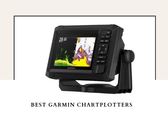
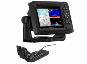
1) Garmin ECHOMAP UHD2 53CV Chartplotter
The Garmin ECHOMAP UHD2 53CV Chartplotter is the best Garmin chartplotter, delivering exceptional performance in a user-friendly, space-efficient design, with wifi connectivity, and brilliant ClearVü sonar. Boasting a bright 5” color display, this chartplotter strikes the perfect balance between portability and readability, making it an excellent choice for small to mid-sized boats.
Its keyed interface ensures quick operation even with wet or gloved hands, ideal for serious anglers in unpredictable conditions.
One of the 53CV’s biggest strengths is its dual sonar capability. By combining Garmin’s CHIRP traditional sonar with ClearVü scanning sonar, the unit delivers sharp, detailed underwater imagery.
The high-contrast, vivid color palettes enhance target separation and make distinguishing fish from structure a breeze. This dual sonar setup ensures you don’t just see the fish, you understand the underwater environment they’re hiding in.
The 53CV is preloaded with LakeVü g3 inland maps, giving you unparalleled mapping detail right out of the box. These maps include depth contours, navigation aids, and more, all powered by Navionics data. If you boat or fish in coastal waters, you can upgrade to Garmin’s BlueChart g3 or Navionics+ cartography for added detail and functionality.
Add to that the ActiveCaptain app integration via built-in Wi-Fi, and you get a powerful on-the-go tool for syncing software updates, accessing the Garmin Quickdraw Community, and utilizing OneChart™ to manage your maps and charts effortlessly.
Another major advantage of the UHD2 53CV is its wireless networking capability. If you’re running multiple compatible chartplotters on your boat, this feature allows you to share sonar, waypoints, and routes seamlessly across screens, something typically found in higher-end models. This interoperability makes it a smart investment for anglers building a more integrated marine electronics setup.
Pros
- Crisp 5” keyed color display for easy use in all conditions
- Dual sonar (CHIRP traditional + ClearVü scanning) provides clear, detailed underwater views
- Vivid color palettes improve target and structure distinction
- Preloaded with LakeVü g3 inland maps based on Navionics data
- Wireless connectivity for sharing sonar and data with other Garmin units
- ActiveCaptain app integration for updates, community charts, and mobile access
- Compact size ideal for kayaks, jon boats, and small fishing vessels
Cons
-
No touchscreen functionality (keyed only)
2) Garmin ECHOMAP UHD2 94sv Chartplotter
The Garmin ECHOMAP UHD2 94sv Chartplotter is one of the best Garmin chartplotters for serious anglers and boaters seeking advanced sonar, detailed navigation, and seamless connectivity. With its large 9” high-resolution touchscreen display and keyed-assist interface, this model offers a refined and responsive user experience.
Whether you’re navigating coastal waters or scanning for fish, the bright, sunlight-readable screen ensures visibility and control in all conditions, even under harsh glare or from wide viewing angles.
At the core of the 94sv’s performance is the included GT56-TM transducer, supporting Garmin traditional sonar, ClearVü, and SideVü scanning technologies. These sonar modes work together to deliver crisp fish arches, structure identification, and wide underwater coverage in stunning detail.
With vivid color palettes, targets and contours pop with clarity, giving anglers a competitive edge when locating fish or navigating tricky waters. For those who want even more advanced sonar capability, the unit also supports Garmin’s LiveScope™ systems.
Navigation is another major strength of the UHD2 94sv. It comes preloaded with Garmin Navionics+ coastal charts, featuring rich detail and integrated Navionics data that give you confidence and precision whether you’re charting familiar waters or exploring new territory. Enhanced by multi-band GPS, the device provides improved positional accuracy, even in challenging environments with reflected or weak signals.
One of the most appealing features of this unit is its built-in Wi-Fi, which allows for wireless sharing of sonar, waypoints, and routes with other compatible ECHOMAP UHD2 chartplotters.
It also connects effortlessly to the Garmin Force trolling motor, allowing users to create and follow routes, navigate to waypoints, control motor speed, and monitor battery life, all directly from the screen.
Through the ActiveCaptain app, users can access OneChart, software updates, and more, making the ECHOMAP UHD2 94sv a truly integrated command center for any boat.
Pros
- Large, bright 9” touchscreen with excellent detail and wide viewing angles
- Includes GT56-TM transducer with traditional, ClearVü, and SideVü sonar
- High-contrast, vivid color palettes make sonar imagery easier to interpret
- Built-in Garmin Navionics+ coastal charts with integrated Navionics data
- Supports LiveScope sonar for even more advanced fishfinding
- Wi-Fi connectivity for sharing data between ECHOMAP UHD2 units
- Compatible with the Force trolling motor for advanced vessel control
- Multi-band GPS improves positional accuracy
- NMEA 2000 compatible for connecting additional marine electronics
Cons
-
Premium features come at a higher price point
3) Garmin ECHOMAP UHD 73sv Chartplotter
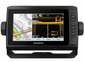
The Garmin ECHOMAP UHD 73sv strikes the perfect balance between size, functionality, and affordability, making it one of the best Garmin chartplotters for both casual and committed anglers. Featuring a bright, 7-inch sunlight-readable touchscreen with keyed assist, the display offers excellent visibility even under harsh glare, while providing a user-friendly interface for easy control in rough water or while wearing gloves.
One of the best features is its support for the GT54 transducer, which unlocks Ultra High-Definition ClearVü and SideVü scanning sonars. These sonar technologies deliver crisp, detailed imagery of structure, cover, and fish, both below and to the sides of your boat.
Paired with Garmin high-wide CHIRP traditional sonar, the 73sv excels in target separation and depth penetration, helping you locate and identify fish with incredible accuracy.
It’s also compatible with Panoptix and Panoptix LiveScope sonar, offering even more advanced real-time views of fish and structure if you choose to upgrade.
Navigation is a strong suit thanks to the preloaded LakeVü G3 inland maps, which combine Garmin and Navionics data to cover over 17,000 lakes in the U.S., with 1’ contours for exceptional detail.
This makes it an ideal unit for freshwater anglers looking to map out drop-offs, ledges, and submerged cover with precision. The quick-release bail mount makes it easy to remove the unit and take it with you, whether for security or convenience.
Connectivity is another big win. The ECHOMAP UHD 73sv supports both NMEA 2000 and NMEA 0183 networking, allowing integration with engine data, sensors, and autopilot systems.
It can also share sonar, waypoints, and routes with other ECHOMAP UHD, UHD2, Plus, and Ultra units onboard. Additionally, it’s compatible with the Garmin Force trolling motor, giving you full control from the screen, navigate to waypoints, follow depth contours, or route your path with ease.
Pros
- Bright, responsive 7” touchscreen with keyed assist for versatile control
- Supports high-performance GT54 transducer with UHD ClearVü and SideVü sonar
- Preloaded LakeVü G3 inland maps with 17,000+ lakes and 1’ contours
- Compatible with Panoptix and LiveScope sonar for real-time underwater views
- Quick-release bail mount for easy removal and transport
- Sonar and waypoint sharing with other Garmin chartplotters
- NMEA 2000/0183 support for comprehensive system integration
- Force trolling motor compatibility for seamless vessel control
Cons
-
No built-in Wi-Fi (unlike UHD2 models) for wireless data sharing
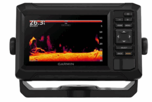
4) Garmin ECHOMAP UHD2 54CV Chartplotter
The Garmin ECHOMAP UHD2 54CV proves that big performance can come in a small package. This 5” chartplotter/fishfinder combo is one of Garmin’s best compact offerings, ideal for anglers and boaters who want powerful sonar and mapping capabilities without taking up too much space on the console. Its bright, keyed display is built for convenience, offering reliable operation even with gloves or in rough conditions.
The UHD2 54CV delivers impressive underwater imaging thanks to dual sonar technology: Garmin CHIRP traditional sonar for excellent target separation and ClearVü scanning sonar for detailed structure and object identification below the boat. Paired with vivid color palettes, the sonar display becomes even more intuitive, making fish and structure pop with high contrast and clarity.
Navigation and mapping are another strong suit of this device. It comes preloaded with LakeVü g3 inland maps and BlueChart g3 coastal charts, integrating Navionics data to give anglers unparalleled coverage and accuracy.
Whether you’re fishing inshore saltwater or exploring inland lakes, this chartplotter gives you a local’s insight into underwater terrain. You can also upgrade to Garmin Navionics+ or Vision+ for even more detailed marine cartography.
Despite its compact size, the UHD2 54CV includes built-in Wi-Fi, which allows wireless sharing of sonar, routes, and waypoints between compatible ECHOMAP UHD2 units on board. Additionally, you can pair it with the ActiveCaptain app to manage your maps, download software updates, and access community-sourced Garmin Quickdraw contour data, all from your smartphone.
Pros
- Compact 5” display with bright, sunlight-readable screen and easy-to-use keyed interface
- Dual sonar capability: CHIRP traditional and ClearVü scanning sonar
- Vivid high-contrast color palettes for clearer fish and structure identification
- Preloaded LakeVü g3 and BlueChart g3 maps with integrated Navionics data
- Built-in Wi-Fi for sharing sonar, routes, and waypoints with compatible units
- ActiveCaptain app integration for mobile control, updates, and map management
- Supports upgradeable Garmin transducers for flexible sonar performance
Cons
-
A smaller screen size may limit usability for split-screen viewing
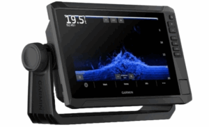
5) Garmin ECHOMAP Ultra 2 12-Inch 126sv Chartplotter
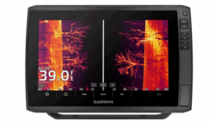
If you’re looking for a powerhouse chartplotter built to deliver top-tier sonar performance, mapping detail, and seamless connectivity, the Garmin ECHOMAP Ultra 2 126sv stands out as one of the best Garmin Chartplotters. This 12-inch chartplotter boasts a massive sunlight-readable touchscreen that gives you maximum visibility and control on the water, whether you’re navigating complex waterways or tracking fish beneath the surface.
The Ultra 2 126sv is engineered for serious anglers and comes preloaded with Garmin Navionics+™ U.S. Inland and Coastal maps, offering extensive detail and accuracy for both saltwater and freshwater fishing. It also supports Garmin Navionics Vision+ for high-resolution relief shading and satellite imagery, elevating your navigational awareness to a whole new level.
For sonar capability, the ECHOMAP Ultra 2 supports Ultra High-Definition scanning sonar and CHIRP traditional sonar (with transducer sold separately), giving you incredibly detailed views of structure, baitfish, and target species.
It also fully supports Garmin’s LiveScope system, allowing you to add forward-facing sonar for real-time, live scanning that revolutionizes how you locate fish. The vivid color palettes enhance sonar contrast, making it easier to interpret readings at a glance.
Connectivity is a major strength of this unit. The ECHOMAP Ultra 2 wirelessly networks with compatible ECHOMAP Ultra 2 and UHD2 units, allowing for seamless sharing of sonar, waypoints, and routes.
The unit includes multi-band GPS for enhanced accuracy, especially useful when fishing near cover or navigating tight coastal routes. It even allows screen recordings, so you can capture and share your catches or review your sonar footage later, perfect for learning or content creation.
Pros
- Large, sunlight-readable 12” touchscreen with ultra-clear display
- Preloaded with Garmin Navionics+ for U.S. inland and coastal mapping
- Supports UHD scanning sonar, CHIRP sonar, and LiveScope live sonar systems
- Vivid color palettes for easier sonar interpretation
- Multi-band GPS provides faster, more accurate positioning
- Wireless sharing of sonar, routes, and waypoints with other compatible units
- Screen recording capability for sharing and reviewing fishing trips
- Compatible with premium Garmin Navionics Vision+ maps
Cons
-
The transducer and LiveScope system are sold separately
Next Read: 6 Best Fish Finders for Pontoon Boats
Factors to Consider when Choosing the Best Garmin Chartplotters
Here are the most important factors to consider when choosing the best Garmin chartplotters, each explained in detail:
Screen Size and Readability
The display is one of the most important aspects of any chartplotter. Larger screens offer more real estate for viewing maps and sonar simultaneously, which is crucial for situational awareness on the water.
A bright, sunlight-readable display ensures you can see charts and sonar images even in direct sunlight. Touchscreen models with keyed assists offer a balance of intuitive navigation and physical button control, which can be especially helpful in rough conditions.
Sonar Capabilities
A quality chartplotter should offer a combination of sonar technologies to provide a comprehensive view beneath the surface. CHIRP traditional sonar delivers clear target separation, while scanning sonar technologies like ClearVü and SideVü provide detailed images of structure and fish.
Some units also support live-scanning sonar for real-time views of moving fish and objects. The more advanced the sonar support, the better your chances of locating fish and understanding underwater terrain.
Mapping and Chart Coverage
Preloaded maps and the ability to expand mapping options play a vital role in navigation. Look for models that come with detailed inland or coastal maps, featuring high-resolution contours and integrated data.
Some chartplotters offer support for additional mapping upgrades, including relief shading and satellite imagery. The more detailed and extensive the chart coverage, the safer and more efficient your navigation will be.
Networking and Sharing
If you plan to install multiple units on your boat, networking capabilities are essential. High-end chartplotters allow for wireless or wired sharing of sonar data, waypoints, and routes across compatible devices.
This means you can have multiple screens onboard, each displaying the data you need in different locations. Efficient networking ensures better coordination and flexibility during fishing or navigation.
GPS Accuracy and Performance
A reliable chartplotter must offer accurate and fast positioning. Multi-band GPS systems provide enhanced location precision, especially useful in areas with poor signal reception or near obstructions.
Improved accuracy helps with route planning, waypoint marking, and maintaining course in challenging conditions. Quick and accurate GPS acquisition can make a significant difference in navigation efficiency.
Compatibility with Accessories
Many advanced anglers look for units that support a range of accessories such as trolling motors, autopilot systems, and external sensors. Integration with trolling motors, for example, allows users to control movement and navigation directly from the chartplotter screen. Compatibility with accessories increases the chartplotter’s utility and streamlines control of your entire onboard electronics setup.
User Interface and Ease of Use
An intuitive interface can dramatically improve the user experience. Whether through touchscreen controls, keypad shortcuts, or a combination of both, ease of use allows you to quickly access important functions without unnecessary complexity.
Well-designed menus, customizable layouts, and easy-to-read graphics make your time on the water more productive and less frustrating.
Portability and Installation Flexibility
Some chartplotters offer quick-release mounts or compact designs that are easy to remove and store when not in use. This portability is beneficial for anglers who switch between boats or want added security when docked.
Additionally, flexible installation options allow the chartplotter to be mounted in a way that best suits your helm layout and preferences.
Advantages of Garmin Chartplotters
Advanced Sonar Technology
Garmin chartplotters offer a powerful range of sonar options including CHIRP traditional, ClearVü, SideVü, and support for live-scanning sonar systems.
These technologies provide crisp, high-resolution views of what’s beneath and around your boat, helping anglers distinguish between fish, structure, and bottom features with greater accuracy. This sonar’s versatility enhances both recreational fishing and professional use.
High-Quality Displays
Garmin chartplotters are known for their bright, sunlight-readable screens that range from compact 5” models to expansive 12” touch displays. These screens use vivid color palettes to improve sonar readability and ensure visibility in harsh lighting conditions.
Whether you’re viewing charts or sonar images, the display clarity greatly enhances your ability to interpret data at a glance.
Preloaded and Expandable Mapping
With integrated mapping such as LakeVü g3 and BlueChart g3, Garmin chartplotters come ready with detailed inland and coastal coverage. These preloaded maps include up to 1’ contours and Navionics data.
Users can further enhance navigation by upgrading to Garmin Navionics+ or Vision+ for advanced features like relief shading and satellite imagery, making them extremely useful for precise route planning and fishing in unfamiliar waters.
Wireless Networking and Data Sharing
Many Garmin chartplotters support wireless networking, allowing compatible units to share sonar, waypoints, and route data. This connectivity simplifies multi-unit setups and provides seamless communication between helm stations.
It enhances efficiency by reducing the need for duplicated inputs and makes it easier to manage navigation and fishfinding from multiple screens.
Accessory Compatibility and System Integration
Garmin chartplotters are compatible with a wide range of accessories, including trolling motors, autopilot systems, NMEA 2000 sensors, and external GPS antennas.
This integration allows anglers and boaters to centralize control, monitor engine data, or steer automatically—all from a single screen. The ability to expand functionality ensures that the chartplotter can grow with your boating needs.
ActiveCaptain and Mobile App Integration
Garmin’s built-in Wi-Fi capabilities allow chartplotters to connect with the free ActiveCaptain app, unlocking access to OneChart, software updates, and community-sourced Quickdraw data.
This mobile integration keeps your system up to date and allows remote planning and syncing of routes, offering a modern and flexible user experience that extends beyond the helm.
Conclusion
Choosing the best Garmin chartplotters involves understanding the features that matter most, whether it’s sonar performance, mapping capabilities, display quality, or system connectivity.
Across their range, Garmin delivers a seamless blend of innovation, durability, and ease of use, giving users the confidence to explore new waters and fish more effectively.
No matter your experience level or intended use, Garmin chartplotters provide a solid foundation for smarter navigation and more productive time on the water.